After several rain complication delays, the Pickawillany field work has finally started. The first course of the work, and the most important, was re-establishing the site grid. This grid covers the 30-some acres of the site and will be used to:
1. Measure in the location of artifacts recovered during the metal detecting portion of the work.
2. As reference points for the geophysic survey.
3. To help locate geophysic target anomalies for excavation.
![]()
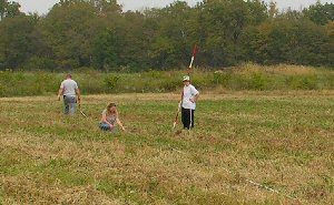
Once the main reference points (a.k.a. datums) were located Bill Pickard used a transit to “shoot in” straight grid lines (picture 1). Chaining pins were placed at correct intervals along the measured line. In picture 2, Urbana University intern, Michael Thornton is in charge of moving the coated steel measuring tape into line, volunteer Revonda Gentry is placing a chaining pin into the desired position and Piqua Historical Area staff person Diana Jacobs is in charge of the stadia rod which is used as a visual aid helping Bill create the straight grid line. Afterward the chaining pins were replaced by wooden stakes which were marked with the grid point location and flagging tape.
To give you a good idea of the scale of this endeavor, picture 3, is a knitted together (yes, pretty badly knitted at that) picture of the area they were working. They are just below the tree line. Bill is one the left, Revonda and Diana are in the center and Michael is toward the right.![]()