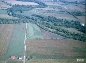
From early October through mid-November archaeologists from the Ohio Historical Society, aided by students and volunteers, will continue the archaeological survey of the site of Pickawillany in northern Miami County, Ohio. Pickawillany was a large Miami Indian town located at the confluence of Loramie Creek and the Great Miami River at about the mid-point of the 18th century (picture 1 shows the 2 rivers and the Pickawillany area).
In 1748, the English opened a trading post there much to the irritation of the French who claimed the Ohio Country as their own. The site consisted of a stockaded blockhouse and several traders cabins as well as a large number of Native American structures that included a council house. The explorer Christopher Gist described Pickawillany in 1751 as “consisting of 400 families and daily increasing it can be counted as one of the strongest Indian towns on this part of the continent”. Over the next couple of years attempts by the French to win back their trade alliance with the Miami were rejected by the Miami Chief Memeskia, who preferred to trade with the English. Because of his close ties to the English traders, Memeskia soon began to be referred to as Old Briton. On the morning of June 21, 1752, Pickawillany was attacked and destroyed by a force of 250 Ottawa and other northern Indians led by the French metis Charles Langlade. The assault was quick and decisive and over by mid-afternoon. Several Indians were killed and most of the English traders either killed or captured. A wounded Old Briton was brought to Langlade where, it is said, he met a fate worse than mere death. After looting the village and trading post, Langlade and his small army departed with their prisoners in tow. It is interesting to note that some historians see the assault on Pickawillany as the initial shots of the French and Indian War. This may or may not be true. However, the rise and fall of Pickawillany is a fascinating story and remains the earliest, well documented episode in Ohio’s history.
This years work by the OHS archaeologists will be to continue the remote sensing and comprehensive metal detector survey of the 37.5 acre tract begun in 2002. The tract was purchased by the State of Ohio in 1999 to be included in the Piqua Historical Area State Memorial and overseen by the Ohio Historical Society. The site has been actively farmed since the mid 1800s and no visible traces of Pickawillany remain.
Remote sensing involves the use of sophisticated instruments and is a nondestructive means to see what might be under the surface without having to do extensive digging. The primary remote sensing technique to be used in this years survey will be the testing of soil electrical resistance. The resistance data will be used to compliment magnetic gradient data collected in previous field seasons. Remote sensing instruments are particularly useful in locating burned areas, building foundations, trash pits, dumps and other buried features not readily apparent at the surface. Because of the cost of the instruments and the expertise needed to properly interpret the data, this part of the survey will be conducted by Dr. Jarrod Burks of Ohio Valley Archaeology Inc.
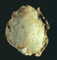
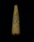
So far, nearly 1300 artifacts have been recovered including musket balls (picture 2) and lead scrap, small brass ornamental items called tinkler cones (picture 3), brass arrow points (picture 4), gun flints, iron tools and the like; they are bits of everyday life on the Ohio frontier at the mid-point of the 18th century. Many are concentrated in clusters that may correspond to activity areas related to Pickawillany. Remote sensing data collected so far has indicated several sub-surface anomalies that may represent parts of building foundations, buried cellars and a well. The primary goal of OHSs ongoing project is to bring a sense of order to the site and perhaps identify the locations of important structures. Such work will make it possible for the Ohio Historical society to present the site to future visitors to the site in ways that will allow them to more fully experience the historical significance of Pickawillany and the human drama that played out there on that June morning more than two hundred and fifty years ago.
Public tours of the site while fieldwork is underway have been tentatively scheduled for Wednesday afternoons between the hours of 1:00 and 3:00. This blog will provide updates on how the work at Pickawillany is progressing.
![]()
The Piqua Historical Area State Memorial is located about 3 miles north of Piqua, Ohio at 9845 North Hardin Road, Piqua, OH 45356.