Fort Laurens Renovation Project Week of August 3-7, 2026
Posted August 7, 2026

Week of August 3-7, 2026

Aug 7

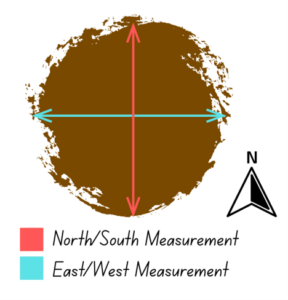
This week I can finally share some of the data we have collected from the post molds about the construction of the fort. This data comes from the northern wall and bastion, where we uncovered 201 post molds across twenty-nine 2m x 1m units. We then took the east/west diameter measurements from 100 post molds from across the wall and bastion and compared them (Photo 1 below).

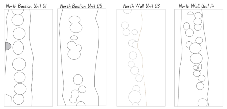
We found that the posts from the bastion are approximately one inch larger in diameter than the posts in the northern curtain wall. The mean diameter of post molds from the bastion is 8.16 in., while the curtain wall has a mean post mold size of 7.16, a size difference of 1 in. The median size of the bastion post molds follows the same conventions and is 1.12 in. larger than those in the curtain wall, suggesting that this size difference is not due to statistical outliers, or, in this case, not due to the presence of a few unconventionally large post molds. The bastion posts are also more consistent in size, with an overall relative variation of 23.2% and a within-unit relative variation of 19.4%. The post molds in the northern curtain wall have an overall relative variation of 25.8% and an in-unit relative variation of 22.9%.

Example of how archaeologists measure a post mold during the 2026 Fort Laurens Renovations.

Photo 1: Example of how we measure a post mold

Drawing that compares the post mold drawings from the north bastion (left) and north curtain wall (right) at Fort Laurens during the fort reconstruction projection. You can see that the bastion molds are more uniform in size and in line, and the wall molds are many different sizes and all over the place.

Photo 2: Comparing the post mold drawings from the north bastion (left) and north curtain wall (right), you can see that the bastion molds are more uniform in size and in line. The wall molds are many different sizes and all over the place.

This pattern fits the construction records of the fort, which indicate that the bastion walls were built first, even though the curtain walls make up 85% of the total fort perimeter (Photo 2). The curtain walls have smaller and more irregular post molds, which could reflect a combination of the dwindling selection of choice nearby timber, pressure to finish the build and a lack of nutrients for the builders. It took 4-5 men to fell and carry one log and they traveled up to a mile away to locate them. Each log weighs between 300 and 400 lbs, or approximately 46.3lbs per cubic foot. The human body uses 80% of its energy on vital functions like breathing, leaving only 20% for extracurricular activities like building a fort. The soldiers were already eating limited rations and were not clothed for the winter, so much of their energy went towards keeping their bodies warm.

All of this data corroborates the written records of the fort's construction. The bastion’s larger and more consistently sized posts are consistent with the men using the best timbers for their primary defensive areas and also possibly due to having more energy to construct evenly. The northern curtain wall having smaller and more irregular posts may show that the men were under pressure from multiple angles to finish the construction as quickly as possible. If they spent their energy and good timber on the bastions, it makes sense that the walls are a bit wonky. In our first blog post, I talked about the interesting inner bastion corners, where clusters of large logs were placed. We think this is evidence of deliberate structural reinforcement in these corners. The northern curtain wall has more gaps between the postmolds, where the soldiers would have put smaller tree limbs or chinking, rather than keeping the posts tight and reinforced like the bastion.

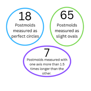
This image shows variations in post mold shapes during the Fort Laurens fort reconstruction in 2026. 18 post molds measured as perfect circles. 65 post molds measured as slight ovals. 7 post molds measured on an axis more than 1.5 times longer than the other.

Photo 3: Showing variations in post mold shapes.

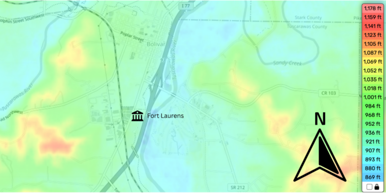
Topographic map of the Fort Laurens area. Low points are in blue/green, and higher points are in yellow/red. Highway 77 is where the Tuscarawas river flowed during the forts occupation period.

Photo 4: Topographic map of the Fort Laurens area. Low points are in blue/green and higher points are in yellow/red. Highway 77 is where the Tuscarawas river flowed during the forts occupation period.

It is a shame that the Ohio-Erie Canal removed the eastern bastions and walls, as getting data from all four walls could help us determine which order they were built in (Photo 3). We assume the western and southern walls were built first. Our logic goes like this: the frozen river provided an eastern barrier to the fort and they could see long-distance to the west and north/northwest, but the hills to the south/southwest posed real danger to the fort (Photo 4).

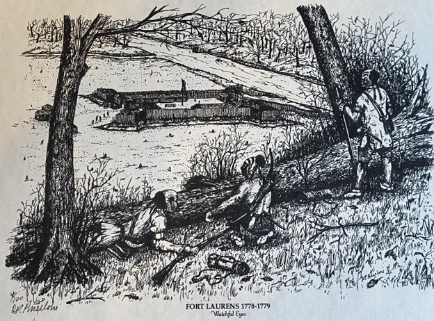
The hills in the southern end of the modern park are where the British-aligned indigenous groups ambushed and killed twenty men. From a defensive point, the southern and western walls seem to be the most important (Photo 5). To confirm this, we will look for consistently sized post molds with regular spacing in the fort’s remaining southern bastion. Unfortunately, our units in the southern portion of the western wall did not yield many post molds, and we haven’t crunched the numbers for the northern half of the western wall. The data eludes us, but we will find it!

Drawing by Doug Angeloni showing Photo 5. The vantage point over Fort Laurens from the southern hills.

Photo 5: The vantage point over the fort from the southern hills. Drawing by Doug Angeloni

Onto this weeks work…

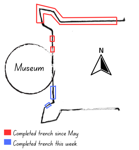
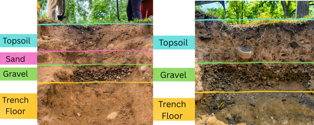
This week, in the southern half of the western wall, we dug six 2M x 1M units just southeast of the museum and found post molds in one of them (Photo 6). This is a huge difference from the units in the northern half of the fort, where we only had one or two units without post molds. Our current theory is the difference in the fill techniques used by Dr. Gramly in the previous 1970s excavations. We refer to this fill layer of soil as “Gramly fill.” In the northern half of the fort, the Gramly fill consisted of a layer of sand placed atop a layer of gravel, effectively creating a French drain. Thus far in the southern half, the fill consists of mixed soil and gravel (see Photo 7). This difference in fill affects the way the soil absorbs water - a French drain collects water and provides it a place to go, but the mixed soil and rocks soak up water in the same way ground soil does. Perhaps this difference in water draining changes the way the post molds look. We’re not really sure.

Work we completed since May 2026 in red, and work archaeologists at Fort Laurens completed in August 2026 in blue.

Photo 6: Work we completed since May in red and work we completed this week in blue.

Photo 7: Images showing the difference between the trench fill from the northwestern bastion (left) and the western wall (right).

Author: Sarah E. Leitch
Data & post mold drawings: Jon Brewster

Subscribe to Our Blogs